[ENG] A National Monument / [ESP] Un Monumento Nacional
[ENG] A National Monument
Source
Hello friends, I greet you with great respect from the Bolivarian Republic of Venezuela. Today I appear here to share with you part of our national history. History that involves the architecture and military engineering after the Spanish conquest of our territory. History of the time in which we were a colony of the kingdom of Spain. Time of pirates, filibusters and corsairs who besieged and tried to conquer the city of Caracas, the main bastion of the monarchy in this part of the world.
Source
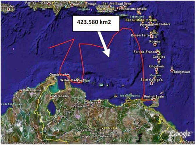
To understand the history a bit, it is good to know that Venezuela has a Caribbean façade (Caribbean Sea) to the north, which includes a total coastal area of 423,580 km2, according to the calculation provided in 1999 by the Directorate of Hydrography and Navigation of the Venezuelan Navy. The linear Caribbean facade is 2813 km of coastline. that goes from Punta Castillete, in the Guajira Peninsula, to Punta Peña in the Paria Peninsula, which shares coasts, maritime and air spaces with Colombia, Trinidad and Tobago, the Greater Antilles: Cuba, Santo Domingo, Jamaica and Puerto Rico and the Lesser Antilles (The Lesser Antilles or Lesser Antilles are the group of islands in the Caribbean Sea formed by the smaller Antilles, which form an insular arc to the southeast of the Greater Antilles, which extends from the east of Puerto Rico to the western coast of Venezuela), being our main entrance and exit and commercial and tourist interaction with the world by sea.
Main countries belonging to the Lesser Antilles: Antigua and Barbuda, Barbados, Dominicans, Grenada, Saint Kitts and Nevis, Saint Vincent and the Grenadines, Saint Lucia, Trinidad and Tobago. The Virgin Islands belonging to the United States. Guadalupe, Martinique, San Martín and San Bartolomé belonging to France. Aruba, Bonaire, Curaçao, Saba, Saint Eustatius, Sint Maarten, known as the Netherlands (The Netherlands Antilles or Dutch, of the Netherlands or Holland). Anguilla, British Virgin Islands and Montserrat belonging to the United Kingdom; as well as the Island of Margarita that belongs to the Bolivarian Republic of Venezuela ... among other islands.
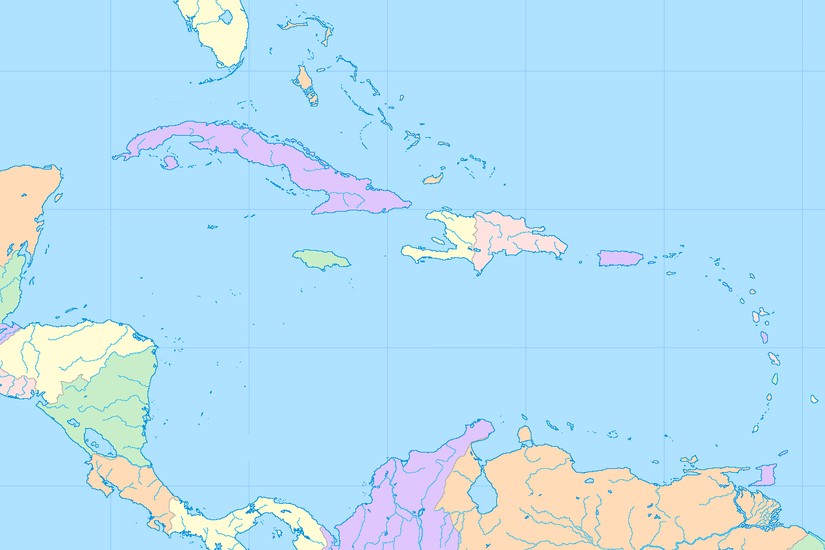
Here you can see the location of the Lesser Antilles. Source
That great maritime extension; Although it is true that it is located in a privileged geostrategic place in the American continent, it is no less true that its wide coastline was vulnerable in remote times. Pirates, privateers, filibusters and whatever invaders sailed through these seas threatened and besieged the territory of the former Spanish colony many times.
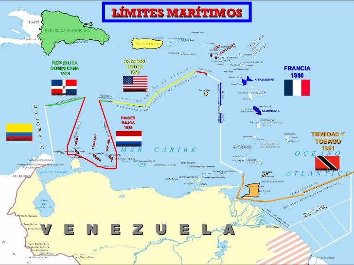
Maritime limits of the Bolivarian Republic of Venezuela with some countries Source
Having clarified this, by way of introduction and general information, I will proceed to the essence of the post that I want to share with you. It turns out that on a day like today, April 13 but in 1976, El Castillo Negro is declared a National Historic Monument of Venezuela. Now, you may wonder: What does the introduction of this post have to do with El Castillo Negro? Ok, I explain, the city of Caracas, capital of the Bolivarian Republic of Venezuela, was very important for the Spanish monarchy since its foundation (July 25, 1567). Caracas, since the nineteenth century is considered the center of political and economic power in Venezuela. It is located in the north-central coastal area of the country, 12 km from the coast of the Caribbean Sea and is located within a mountainous valley known as Cerro El Ávila or Warairarepano. Caracas is located at almost 900 meters of altitude, separated from the central coast of Vargas, by the Cordillera de la Costa. At present, Caracas and the coastal state, La Guaira, are linked mainly by a highway, but in ancient times to get to Caracas, you had to climb from La Guaira through the aforementioned hill, access was not easy, but if an invader managed to climb could conquer the city. Currently in the State of La Guaira, there is the main airport of the country, the Simón Bolívar de Maiquetía International Airport, and there is also the port of La Guaira, the second most important port of the country in Venezuela.
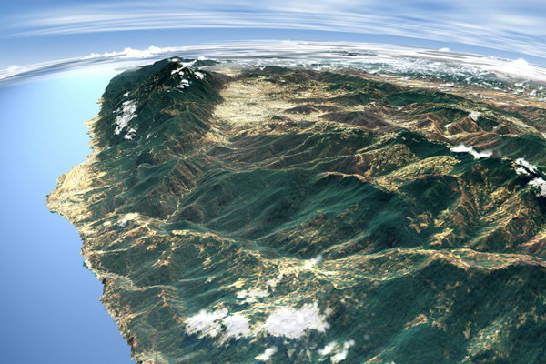
Satellite view of the Caracas valley. Source
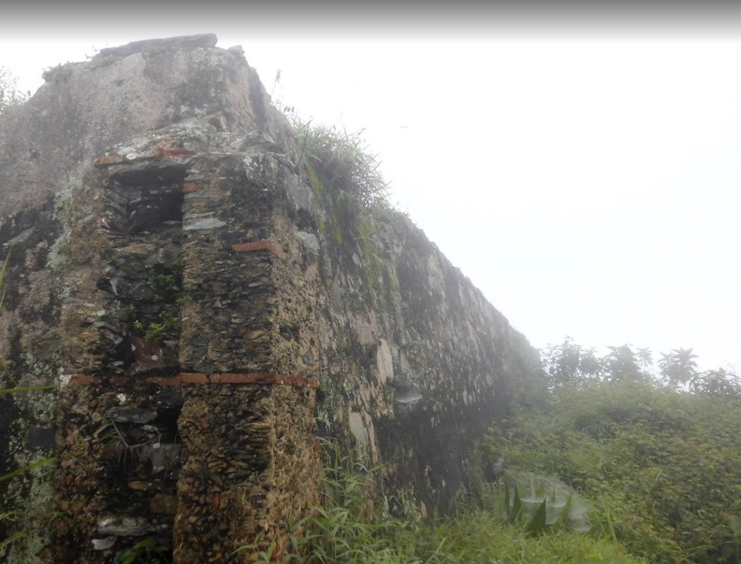
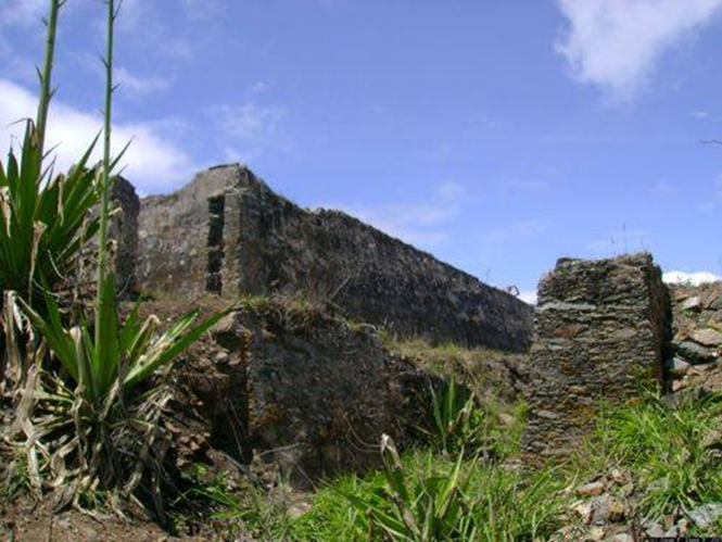
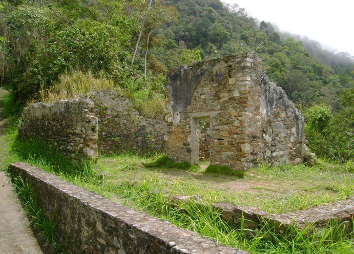
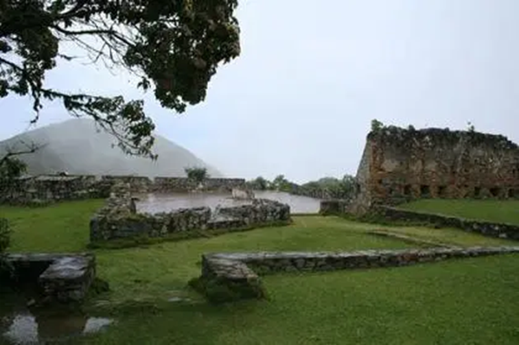
As you can see in the previous photo, Cerro El Ávila or Warairarepano is, by the work and grace of God and nature, a kind of natural wall that protects the city of Caracas and in colonial times this condition was used to the protection of the city. In view of the constant invasion attempts suffered by Caracas, due to the attacks of the English Empire, the Spanish monarchy saw the need to protect the city and the merchants who traveled the only road between the capital and the port of the Guaira (today known as the Camino de los Españoles). For that reason, he ordered the construction of 5 fortresses on the mountain, at various strategic points overlooking the sea and one of those military constructions was EL Castillo Negro, so named because it was painted with charcoal so that it was more difficult to distinguish it from the coast. It was built in 1770 and had a drawbridge, because it was separated from the road by a ravine. The panoramic view where the castle was located is excellent over the Central Coast. Today, April 13, it is 45 years since it was declared a National Monument according to Official Gazette number 30,971.
Source
Source
 Source
[ESP] Un Monumento Nacional
Fuente
Hola amigos, les saludo con mucho respeto desde la República Bolivariana de Venezuela. Hoy aparezco por aquí para compartir con ustedes parte de nuestra historia nacional. Historia que involucra la arquitectura e ingeniería militar posterior a la conquista española de nuestro territorio. Historia de la época en la cual fuimos colonia del reino de España. Tiempo de piratas, filibusteros y corsarios que sitiaban y pretendían conquistar la ciudad de Caracas, principal bastión de la monarquía en esta parte del mundo.
Fuente
Para comprender un poco la historia es bueno saber que Venezuela tiene una fachada Caribeña (mar Caribe) al norte, que comprende una extensión costera total de 423580 Km2, según el cálculo que aportó en 1999 la Dirección de Hidrografía y Navegación de la Armada venezolana. La fachada caribeña lineal es de 2813 km de costa. que va de Punta Castillete, en la Península de la Guajira, hasta Punta Peña en la Península de Paria, la cual comparte costas, espacios marítimos y aéreos con Colombia, Trinidad y Tobago, las Antillas Mayores: Cuba, Santo Domingo, Jamaica y Puerto Rico y las Antillas Menores (Las Antillas Menores o Pequeñas Antillas son el grupo de islas en el mar Caribe formado por las Antillas de menor tamaño, que forman un arco insular al sudeste de las Antillas Mayores, que se extiende desde el este de Puerto Rico hasta la costa occidental de Venezuela) , siendo nuestra principal entrada y salida e interacción comercial y turística con el mundo por vía marítima.
Principales países pertenecientes a las Antillas Menores: Antigua y Barbuda, Barbados, Dominicas, Granada, San Cristóbal y Nieves, San Vicente y las Granadinas, Santa Lucía, Trinidad y Tobago. Las Islas Vírgenes pertenecientes a Estados Unidos. Guadalupe, Martinica, San Martín y San Bartolomé pertenecientes a Francia. Aruba, Bonaire, Curazao, Saba, San Eustaquio, Sint Maarten, conocidos como los Países Bajos (Las Antillas Neerlandesas u Holandesa, de los países Bajos u Holanda). Anguila, Islas Vírgenes Británicas y Montserrat pertenecientes a Reino Unido; así como la Isla de Margarita que pertenece a la República Bolivariana de Venezuela... entre otras islas.
Aquí se pueden observar la ubicación de las Antillas Menores Fuente
Esa gran extensión marítima; si bien es cierto que la ubica en un lugar geoestratégico, privilegiado, en el continente americano, no es menos cierto que su amplia costa fue vulnerable en épocas remotas. Piratas, corsario, filibusteros y cuanto invasor navegaba por estos mares amenazaron y sitiaron muchas veces el territorio de la otrora colonia española.
Límites marítimos de la República Bolivariana de Venezuela con algunos países Fuente
Aclarado esto, a modo de introducción e información general, procederé a la esencia del post que deseo compartir con ustedes. Resulta que tal día como hoy, 13 de abril pero del año 1976, El Castillo Negro es declarado Monumento Histórico Nacional de Venezuela. Ahora bien, ustedes se preguntarán: ¿Qué tiene que ver la introducción de este post con El Castillo Negro? Ok, les explico, la ciudad de Caracas, capital de la República Bolivariana de Venezuela, fue desde su fundación (25 de julio de 1567) muy importante para la monarquía española. Caracas, desde el siglo XIX es considerada el centro del poder político y económico de Venezuela. Está ubicada en la zona centro-norte costera del país, a 12 km de la costa del mar Caribe y se sitúa dentro de un valle montañoso conocido como el Cerro El Ávila o Warairarepano. Caracas se ubica a casi 900 metros de altitud, separada del Litoral central de Vargas, por la Cordillera de la Costa. En la actualidad Caracas y el Estado costero, La Guaira, se unen principalmente por una autopista pero en la antigüedad para llegar a Caracas se tenía que subir de la Guaira a través del cerro antes mencionado, el acceso no era fácil, pero si algún invasor lograba subir podía conquistar la ciudad. En la actualidad en el Estado La Guaira, está el principal aeropuerto del País, el Aeropuerto Internacional Simón Bolívar de Maiquetía, y también se encuentra el puerto de La Guaira, el segundo puerto del país mas importante de Venezuela.
Vista satelital del valle de Caracas. Fuente
Como pueden observar en la foto anterior el Cerro El Ávila o Warairarepano es, por obra y gracia de Dios y de la naturaleza, una especie de muralla natural que protege a la ciudad de Caracas y en la época de la colonia esta condición fue aprovechada para la protección de la ciudad. En vista de los constantes intentos de invasión que sufrió Caracas, a causa de los ataques del Imperio inglés, la monarquía española, vio la necesidad de proteger a la ciudad y a los mercaderes que transitaban por el único camino entre la capital y el puerto de la Guaira (hoy conocido como Camino de los Españoles). Por esa razón mandó a construir 5 fortalezas en la montaña, en varios puntos estratégicos con vista al mar y una de esas construcciones militares fue EL Castillo Negro, llamado así porque era pintado con carbón para que fuese más difícil distinguirlo desde la costa. Fue construcción en 1770 y tenía un puente levadizo, porque estaba separado del camino por una quebrada. La vista panorámica donde se encontraba el castillo es excelente sobre el Litoral Central. El día de hoy, 13 de abril se celebra 45 años de haber sido declarado Monumento Nacional según Gaceta Oficial número 30.971.
Fuente
Fuente
FuenteAuthor, Autor:Marcos E. Milano R
Hello, my friend Marcos! Like Venezuela, the Philippines was also colonized by the Spanish empire for several hundred years during ancient times. No wonder, our countries may have some similarities in language development, cultural and religious influences, plus other significant traditions we practice today. Is restoration work still continued on the El Castillo Negro castle/fortress, and are there still tourists visiting that historic landmark?
Did you just celebrate your birthday @marcosmilano71? If so, here's a Happy Birthday greeting, and I wish you the best of health and more blessings! Hope you had an enjoyable and peaceful special day. 😀
Hello friend Erne. A cordial greeting and with great respect from Venezuela. I'm glad to know that we have something in common. Do you speak Spanish in the Philippines?
Answering your question, yes, indeed, the old way of the Spaniards is still visited by our people and by some tourists. The truth is that the area today is not so crowded because of how dangerous everything has been put here and because of the radical quarantine. As for the remodeling, the truth is that I believe that this is neglected at the moment, I do not think that the works have continued.
Regarding my birthday. Yes, friend, last Sunday, the day of God's Mercy, I was thanking Divine Providence for allowing me one more year of life. So, thank you very much for your congratulations. Thank you for the deference, for that detail of friendship. Greetings and infinite blessings for you and for your loved ones.
Respondiendo a tu pregunta, sí, efectivamente todavía el antiguo camino de los españoles es visitado por nuestra gente y por algunos turistas. La verdad es que la zona hoy no es tan concurrida por lo peligroso que todo se ha puesto aquí y por la cuarentena radical. En cuanto a la remodelación, la verdad creo que eso está descuidado en este momento, no creo que hayan continuado los trabajos.
Con respecto a mi cumpleaños. Si amigo, el pasado domingo, día de la Misericordia de Dios, estuve agradeciéndole a la Providencia Divina por permitirme un año mas de vida. Así que, Muchas gracias por tu felicitación. Gracias por la deferencia, por ese detalle de amistad. Saludos e infinitas bendiciones para tí y para tus seres amados.
Esta es una vista de Caracas desde el camino de los españoles. / This is a view of Caracas from the Spanish road. Source
Cyclists route to practice Mountain Bike. / Ruta de ciclistas para practicar BiciMontaña. Fuente
Trekking / Senderismo.Fuente
Fuente
En cuanto a mi Cumpleaños. Te dejo este enlace y gracias por tu felicitación.
https://hive.blog/hive-148441/@marcosmilano71/celebrando-mi-cumpleanos-en-pleno-confinamiento
Yes, I used to have a subject in Spanish during my college days. But, it has been removed already from the academic curriculum. My Spanish language skills are already rusty so, I'd need to refresh myself on learning this. On the other hand, there are some Spaniards who became permanent residents or citizens of the Philippines and are still continuing to use/speak the language.
We hope the restoration works for El Castillo Negro would move forward and the irresponsible neglect would not be the cause of the complete destruction of this important historic architectural heritage.
Again, Happy Birthday my friend, and I wish you the best always in life!
Hello friend @marcosmilano71. It is surprising to appreciate the ruins of what was a fortress like El Castillo Negro and even more valuable the history behind these buildings. Military architecture has always surrounded our country. Thank you for the valuable information.
Hi friend. Good Morning. Thank you for your comment. If so, everything is surprising: History, Architecture, Engineering and even the characters and places that tell us about the past. I greet you and wish you Happy Day and many blessings. Thanks for comment.
https://twitter.com/MarcosEMilano/status/1381993412929466368
Appreciating the ruins is important they display the history of the place. It was indeed a wonderfully written blog, hope you have a lovely week:)
Congratulations, your post has been added to Pinmapple! 🎉🥳🍍
Did you know you have your own profile map?
And every post has their own map too!
Want to have your post on the map too?
Hello @marcosmilano71, just dropping by to congratulate you for being a part of this week's 21st edition of Architecture Brew.
The Architecture+Design Community is an Active Member of the OCD Communities Incubation Program
Find out more about the community comprehensive guidelines
Good night from Venezuela. Thank you very much friend.