[ESP/ENG] Nos perdimos en una excursión en la montaña - Bosque de pinos / We got lost on a hike in the mountains - Pine Forest
Hoy les contaré una anécdota algo graciosa de hace unos cuantos fines de semana atrás, cuando en compañía de unos amigos y mi hermana @keritroberts nos aventuramos a conocer un famoso bosque de pinos que está relativamente cerca de la ciudad en donde vivo, en San Cristóbal, Estado Táchira - Venezuela.
Entonces, les contaré lo que pasó apreciados Hivers...
Dear Hivers, welcome everyone to my blog, I hope you are doing great, wishing you always find inspiration and the creativity you need to make your posts on this amazing platform.
Today I will tell you a funny anecdote from a few weekends ago, when in the company of some friends and my sister @keritroberts we ventured to a famous pine forest that is relatively close to the city where I live, in San Cristobal, Tachira State - Venezuela.
So, I will tell you what happened dear Hivers....

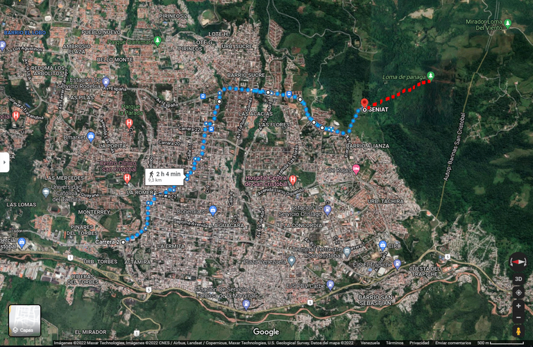
Desde hace mucho tiempo quería visitar el famoso bosque de pinos, pero por cuestiones del destino no había podido hacerlo hasta ese domingo por la mañana, en el que nos atrevimos a visitarlo. Habiendo convencido previamente a los muchachos, nos aventuramos sin saber bien el camino, solo contaba con las referencias de dos personas, mi instinto y nuestro querido GoogleMaps.
En el mapa podrán observar la ruta que seguimos, salimos de casa mi hermana y yo, nos encontramos con uno de nuestros amigos cerca de allí y atravesamos la ciudad, nos encontramos con otra amiga y seguimos nuestro camino hasta llegar a un caserío que queda a pie de la montaña que tendríamos que subir. El tramo en color rojo representa el tramo de ascenso que seguimos hasta llegar a la cima de la montaña, donde se encuentra el bosque.
For a long time I had wanted to visit the famous pine forest, but due to fate I had not been able to do it until that Sunday morning, when we dared to visit it. Having previously convinced the boys, we ventured without knowing well the way, I only had the references of two people, my instinct and our beloved GoogleMaps.
In the map you can see the route we followed, my sister and I left home, we met one of our friends nearby and crossed the city, we met another friend and continued our way until we reached a hamlet that is at the foot of the mountain that we would have to climb. The section in red represents the ascent that we followed until we reached the top of the mountain, where the forest is located.
Al llegar al caserío no teníamos claro cual era la entrada al camino correcto, así que le preguntamos a una señora que se encontraba afuera de su casa, ella amablemente nos indicó cual era el camino correcto para comenzar nuestra travesía montaña arriba.
Comenzamos atravesando un potrero y luego de caminar unos minutos encontramos un cauce de agua que debíamos atravesar, pero estando allí existía la posibilidad de hacer un cambio de planes, conocer una cascada, de la cual no había investigado con anterioridad y cuyo camino según lo que veíamos era subir escalando una a una las enormes piedras por las que fluía el cauce de agua, sin tener una noción al menos vaga de la distancia a la que se encontraba dicha cascada, dada esta situación finalmente seguimos con el plan original.
Atravesamos con cuidado el cause de agua ayudándonos entre todos, inmediatamente después de cruzar nos dimos cuenta de que el camino para llegar a la cima iba a ser bastante exigente. Luego de observar bien el terreno y decidir por donde comenzar a subir específicamente, nos organizamos y subimos uno a uno. El camino de subida estuvo rudo, el terreno era bastante empinado y por un largo tramo estaba mojado, lo que aumentaba el nivel de dificultad y el esfuerzo que debíamos hacer.
En el camino encontramos muchísimos ciempiés, orugas y arañas, estaban por todos lados, especialmente en los troncos de los arbustos y árboles que utilizábamos para sujetarnos e impulsarnos para subir, las muchachas estaban aterradas por esto, pero con cuidado seguimos ascendiendo.
When we arrived at the village we were not sure which was the entrance to the right path, so we asked a lady who was outside her house, she kindly told us which was the right way to start our journey up the mountain.
We started crossing a pasture and after walking a few minutes we found a waterfall that we had to cross, but being there there was the possibility of making a change of plans, to know a waterfall, which had not investigated previously and whose way according to what we saw was climbing one by one the huge stones through which the water flowed, without having at least a vague notion of the distance at which the waterfall was located, given this situation we finally continued with the original plan.
We carefully crossed the waterfall helping each other, immediately after crossing we realized that the path to reach the top was going to be quite demanding. After taking a good look at the terrain and deciding where specifically to start climbing, we organized ourselves and climbed one by one. The way up was rough, the terrain was quite steep and for a long stretch it was wet, which increased the level of difficulty and the effort we had to make.
On the way up we found a lot of centipedes, caterpillars and spiders, they were everywhere, especially on the trunks of the bushes and trees that we used to hold on to and propel us up, the girls were terrified by this, but carefully we continued climbing.
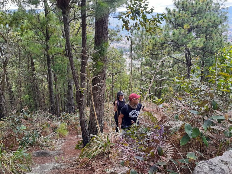
Luego de unas 2 horas superamos el terreno lodoso, comenzamos a caminar sobre un suelo mucho más seco pero no menos exigente. Afortunadamente el camino estaba ligeramente marcado, hubo un ponto donde casi vamos por el camino incorrecto, pero nos dimos cuenta rápido y corregimos el rumbo.
After about 2 hours we overcame the muddy terrain, we began to walk on a much drier but no less demanding ground. Fortunately the path was lightly marked, there was a point where we almost went the wrong way, but we realized it quickly and corrected our course.
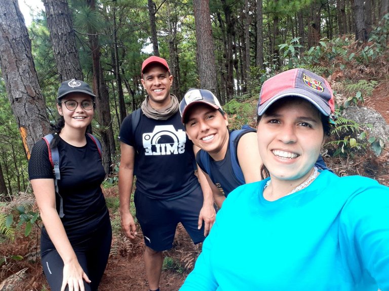
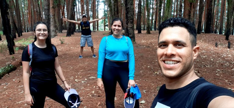
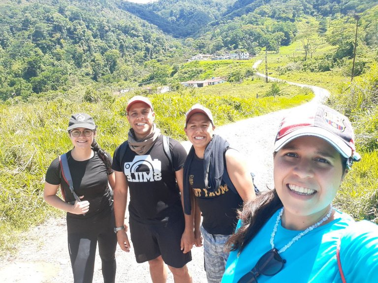
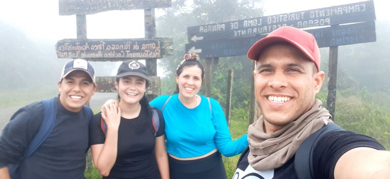
Nos dimos cuenta que a medida que íbamos subiendo, la cantidad de pinos iba aumentando, lo que nos alegró ya que pensamos que debíamos estar cerca de aquel bosque que había visto solo en fotos. Nos reunimos, descansamos un poco, tomamos agua y nos tomamos una foto.
No tengo muchas fotografías del inicio y del transcurso del ascenso, ya que siempre estaba ocupado encontrando la forma de no caerme y ayudando a las muchachas a subir.
We noticed that as we went up, the number of pine trees was increasing, which made us happy because we thought we must be close to that forest that we had seen only in photos. We gathered ourselves together, rested a bit, drank some water and had our picture taken.
I don't have many pictures of the beginning and the course of the climb, as I was always busy finding ways not to fall and helping the girls up.
Luego del ascenso que nos tomó 3 horas aproximadamente, la cima fue conquistada por este aventurero equipo, llegamos al bosque de pinos que por un largo tiempo quise visitar. Estábamos cansados pero eso no logró opacar la alegría de finalmente poder estar allí.
After the ascent that took us approximately 3 hours, the summit was conquered by this adventurous team, we arrived at the pine forest that I had wanted to visit for a long time. We were tired but that did not overshadow the joy of finally being able to be there.
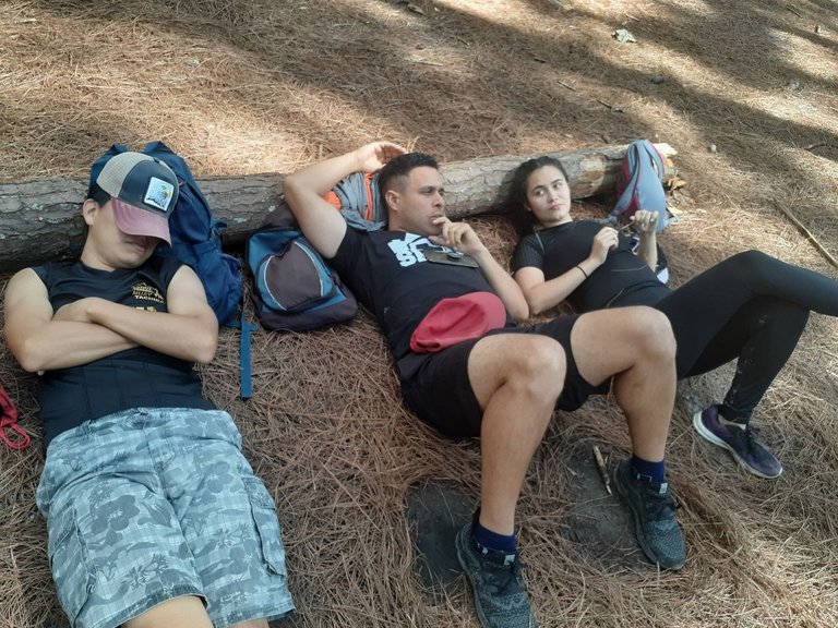
Buscamos un lugar donde descansar allí mismo, como era bien merecido. Encontramos el lugar adecuado para descansar junto a un tronco caído, soltamos nuestras cosas y nos acostamos a descansar, contemplar el paisaje y charlar un poco.
We looked for a place to rest right there, as it was well deserved. We found the right place to rest next to a fallen log, dropped our things and lay down to rest, contemplate the scenery and chat a bit.
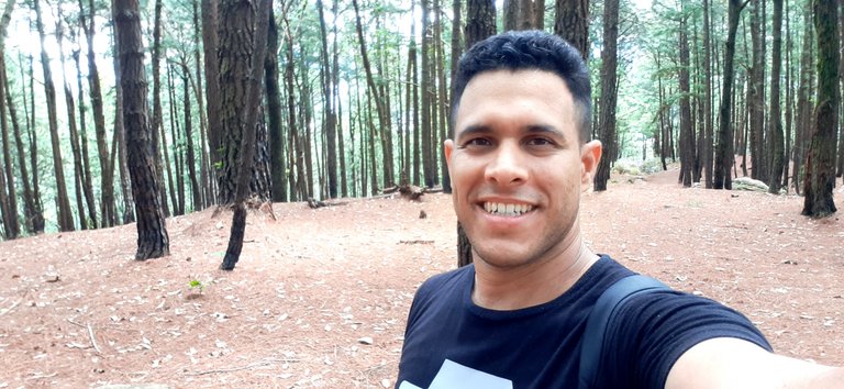
Me tomé una selfie para inmortalizar el momento, donde se viera el claro donde estábamos.
I took a selfie to immortalize the moment, where you could see the clearing where we were.
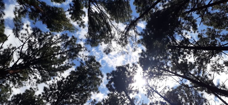
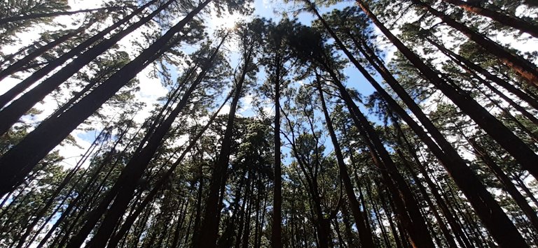
Estando acostado descansando, tomé este par de fotografías desde mi perspectiva. Se veía increíble la combinación y el contraste de los árboles y el cielo, además era hipnotizante ver la danza de las copas de los pinos provocada por el viento.
Lying down resting, I took this pair of pictures from my perspective. It looked amazing the combination and contrast of the trees and the sky, and it was mesmerizing to see the dance of the pine tree tops caused by the wind.
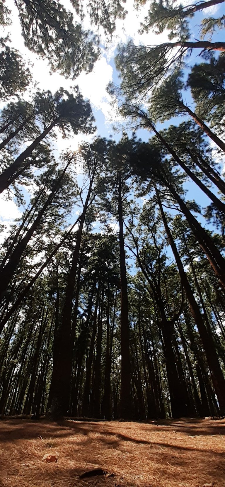
De las fotografías que tomé, esta fue una de las que más me gustó y la comparto con ustedes.
Of the pictures I took, this was one of the ones I liked the most and I share it with you.
Después de disfrutar por un largo rato de aquel fantástico bosque, cubierto por las hojas secas de los pinos -como dato curioso dada su forma particular que asemeja una aguja, cada una recibe el nombre de "Acícula"-, comenzamos a retornar, pero no queríamos bajar por donde subimos, ya que nos parecía algo arriesgado, entonces tomamos otra vía, es allí donde comienza una travesía para encontrar el camino a casa.
Utilicé mi celular para abrir la app de GoogleMaps, esto con la finalidad de obtener mi ubicación y saber dónde se encontraba una vía principal que ya conocía y que nos llevaría a casa, pero a la que no sabía acceder desde donde estábamos. Me ubiqué y logré ver que la vía principal se encontraba montaña arriba, pero al mirar en esa dirección solo veíamos potreros cercados así que descartamos esa opción y consideramos tomar un camino hecho de concreto ya que hice la sugerencia de tomarlo debido a que por allí debían acceder los vehículos de la empresa de electricidad para hacerle mantenimiento a las torres de transmisión eléctrica.
Luego de un rato terminó el camino de concreto y comenzamos uno de tierra en el cual encontramos un toro joven y manso que las muchachas apodaron "Pepe" y que sorpresivamente nos guio por el camino indicado hasta unas rejas que debíamos pasar, seguimos el camino y nos parecía que estábamos bajando y no subiendo, como deberíamos, pero yo trataba de mantener el ánimo ya que en el fondo a pesar de mis dudas sabía que encontraríamos la vía que buscaba.
En un punto del camino cruzamos por un caserío, lo que me dio algo de tranquilidad, allí le pregunté a una señora cual era el camino indicado para volver a San Cristóbal y me respondió que el camino mas adelante que iba hacia arriba, lo cual tenía bastante sentido. Tomamos el camino indicado y caminamos por otro largo rato, vimos otras casas y hasta una especie de club abandonado, este sector se llamaba "Loma de Pánaga", las muchachas ya estaban mucho mas preocupadas porque comenzaba a atardecer, se nos había acabado el agua y aún no llegábamos a la vía principal, a pesar de esto yo seguía tratando de animarlas para que no se angustiaran más de la cuenta.
After enjoying for a long time that fantastic forest, covered by the dry leaves of the pines - as a curious fact given its particular shape that resembles a needle, each one receives the name of "Acícula" -, we began to return, but we did not want to go down where we went up, as it seemed somewhat risky, so we took another road, that is where a journey begins to find the way home.
I used my cell phone to open the GoogleMaps app, this in order to get my location and know where was a main road that I already knew and that would take us home, but I did not know how to access from where we were. I located myself and managed to see that the main road was up the mountain, but looking in that direction we only saw fenced pastures so we discarded that option and considered taking a road made of concrete as I made the suggestion to take it because that is where the vehicles of the electricity company had to access to do maintenance to the transmission towers.
After a while the concrete road ended and we started a dirt road in which we found a young and tame bull that the girls nicknamed "Pepe" and who surprisingly guided us along the indicated path to some fences that we had to pass, we followed the road and it seemed that we were going down and not up, as we should, but I tried to keep my spirits up because deep down, despite my doubts, I knew that we would find the road I was looking for.
At one point we crossed a hamlet, which gave me some peace of mind, there I asked a lady which was the indicated way back to San Cristobal and she answered me that the road ahead was going upwards, which made sense. We took the indicated road and walked for another long time, we saw other houses and even a kind of abandoned club, this sector was called "Loma de Panaga", the girls were already much more worried because it was starting to get dark, we had run out of water and we had not yet reached the main road, despite this I kept trying to encourage them so they would not be more distressed than necessary.
En este punto vi la gloria después de tanto caminar, mi entusiasmo y seguridad lograron convencer al resto del equipo que al fin habíamos llegado a un sitio que conocía bien y donde encontraríamos el camino a la vía principal que buscábamos.
At this point I saw the glory after so much walking, my enthusiasm and confidence convinced the rest of the team that we had finally reached a place I knew well and where we would find the way to the main road we were looking for.
He aquí nuestra foto de celebración, realmente estábamos muy contentos.
Here is our celebration photo, we were really very happy.
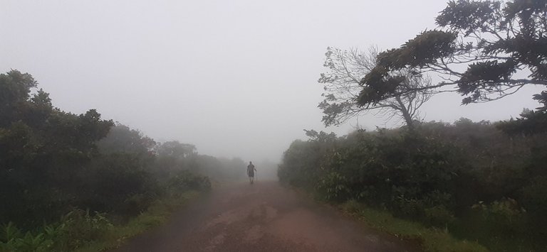
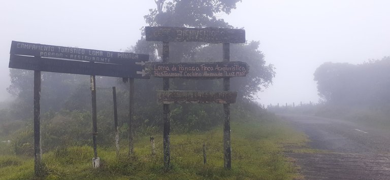
En el camino de bajada había neblina, permitía en algunos tramos hasta 30 metros de visibilidad, entonces le dije a mi hermana que me tomara una fotografía.
On the way down there was fog, allowing up to 30 meters of visibility in some sections, so I told my sister to take a picture of me.
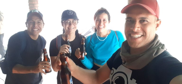
Al encontrar la vía principal, también encontramos una tienda en una casa vieja, donde nos deleitamos con un par de sabrosas e indiscutiblemente merecidas cervezas, luego un par de shots de licor andino típico o "miches andinos", compramos un snack para compartir y nos relajamos un rato, para descansar de la travesía recorrida, charlamos, bromeamos por lo acontecido y finalmente seguimos nuestro camino a casa.
When we found the main road, we also found a store in an old house, where we enjoyed a couple of tasty and unquestionably deserved beers, then a couple of shots of typical Andean liquor or "Andean miches", we bought a snack to share and relax for a while, to rest from the journey, chat, joke about what happened and finally continue our way home.
Hasta la siguiente publicación!
Until the next post!
Todas las fotografías fueron tomadas con un celular SAMSUNG Galaxy A20.
All photographs were taken with a SAMSUNG Galaxy A20 cell phone.
El separador de texto y las demás imágenes son de mi autoría.
The text separator and other images are of my authorship.
Portada realizada en / Cover made in: https://www.canva.com/
Mapa/Map: https://www.google.co.ve/maps/
Translated with: https://www.deepl.com/translator (free version)

https://twitter.com/robertsreinold/status/1494107676795670535
The rewards earned on this comment will go directly to the person sharing the post on Twitter as long as they are registered with @poshtoken. Sign up at https://hiveposh.com.
Lo mejor de todo es que siempre quedan ñas anécdotas 🙈 la neblina es la mejor parte por no se si había frío porque todos se ven con ropa ligera, yo estuviese muriendo si hubiese frío jajaja acá en oriente hay un bosque de pinos también, son pinos que fueron plantados, pero igual es increíblemente hermoso.
Salud por ese trip 🍻
Las anécdotas son lo mejor para después, aún nos reímos al recordar ese día.
Si era baja la temperatura, pero como íbamos caminando cuesta arriba no teníamos frío, ni siquiera en ese tramo de bajada.
Estos bosques son bien bonitos! Salud😅🍻 Saludos!
Es bueno que al menos puedan divertirse. parece una aventura pese a todo!! felicidades por este gran post.
Eso es lo más importante siempre, poder divertirnos en cualquier actividad de este tipo.
Gracias por pasar, leer y comentar!